










Atlanta is a city of contrasts. Soaring skyscrapers rise beyond quiet residential neighborhoods, busy highways curve through thick tree cover, and impressive natural landmarks sit only a short flight from the heart of the city.
From the ground, these places can feel miles apart. From the air, they become part of one extraordinary landscape.
A scenic flight over Atlanta offers a perspective that even longtime residents rarely experience. Familiar buildings become easier to recognize, the city’s famously green canopy stretches toward the horizon, and landmarks such as Stone Mountain, the Chattahoochee River, and Lake Lanier reveal their true scale.
Atlanta Biplane offers routes featuring the city skyline, Downtown and Midtown Atlanta, Stone Mountain, the Chattahoochee River, Lake Lanier, and the area surrounding Truist Park. The exact sights visible during an individual flight can vary according to the chosen route, weather, visibility, and airspace conditions.

A New Perspective on the Atlanta Skyline
The Atlanta skyline is one of the most memorable sights on a city-focused scenic flight. Instead of looking up at individual towers from street level, passengers can see how Atlanta’s main business districts rise from the surrounding neighborhoods.
Downtown and Midtown appear as distinct groups of buildings, connected by busy roads and bordered by parks, homes, and tree-lined communities. From the air, the differences between these areas become much clearer.
Downtown’s closely grouped towers create a dense urban center, while Midtown stretches north with a mixture of office buildings, residential towers and cultural destinations. On a clear day, the skyline may remain visible for much of the flight, changing shape as the aircraft approaches it from different angles.
The All-Atlanta Skyline flight is designed as an introduction to open-cockpit flying while providing broad views of Atlanta’s cityscape. Atlanta Biplane also offers an enclosed-cockpit Piper Cherokee option for daytime, evening, and sunset views over Downtown.

Stone Mountain Rising Above the Landscape
Few Atlanta-area landmarks are as distinctive from the air as Stone Mountain.
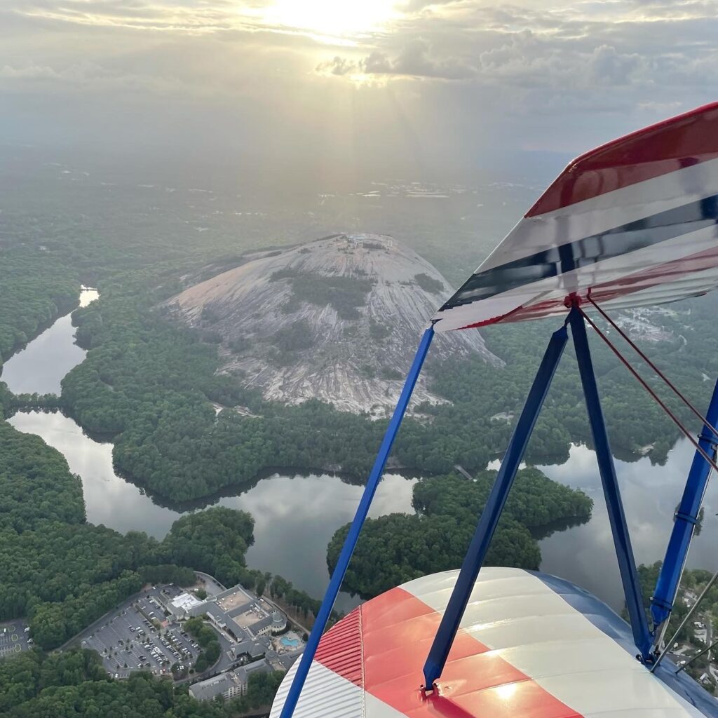
The enormous granite formation rises abruptly from the surrounding forest, making it visible from a considerable distance on clear days. As the aircraft approaches, the mountain’s broad summit, exposed rock, and surrounding lakes begin to take shape.
From above, passengers can appreciate how dramatically Stone Mountain differs from the surrounding landscape. Trails appear as fine lines across the rock, while visitors near the summit can look remarkably small.
Depending on the route and viewing angle, passengers may also see the Summit Skyride cable cars, the Historic Square area, and the carving on the mountain’s north face. Atlanta Biplane’s Historic Stone Mountain flight is specifically designed to provide an aerial view of these park features.
The surrounding park is just as impressive. Woodlands, waterways, recreational areas, and winding roads frame the mountain, creating a view that is difficult to understand fully from any single location on the ground.
The Chattahoochee River
The Chattahoochee River is another landmark that looks far more impressive from above.
At ground level, visitors usually experience only a small stretch of the river at a time. From the air, you can follow its curves across miles of wooded landscape. The water appears and disappears beneath the trees as it winds through the northern and western sides of the metropolitan area.
Roads, bridges, and communities sit surprisingly close to the river, yet the dense tree cover along its banks creates the impression of a protected natural corridor.
The Shoot the Hooch route follows the river after crossing it near GA-400, continuing west and southwest before returning toward the city. This route is particularly well-suited for seeing seasonal color along the river corridor in the fall.

Lake Lanier’s Islands, Coves and Shoreline
Lake Lanier is impressive from almost any viewpoint, but its enormous scale is best understood from the air.
Instead of appearing as one uninterrupted body of water, the lake spreads across the landscape through long channels, sheltered coves and winding inlets. Forested islands and peninsulas create an intricate shoreline that seems to continue toward the horizon.
Boats leave narrow trails across the surface, while marinas and lakeside communities appear along the water’s edge. During the afternoon, sunlight reflects from the open water. Near sunset, the lake can take on warmer shades of gold, orange, and deep blue.
The Big Ol’ Lake Lanier flight is Atlanta Biplane’s longer signature option and is offered as both a daytime and sunset experience. It combines an extended aerial journey with views of major Atlanta-area destinations, subject to weather and FAA airspace limitations.

Atlanta’s Roads Become Part of the View
Atlanta traffic may not feel particularly scenic while you are sitting in it, but the city’s highway system becomes surprisingly interesting from above.
Interstates sweep around the city in broad curves, multilane interchanges form intricate patterns, and streams of vehicles appear far below. I-285 creates a recognizable boundary around much of the city, while routes including I-75, I-85, and GA-400 help passengers identify different parts of the metropolitan area.
These roads also provide a sense of scale. A destination that might take considerable time to reach by car can pass beneath the aircraft in minutes.
Seeing highways, neighborhoods, business districts, and natural landmarks in the same view shows how closely connected Atlanta’s many different areas really are.
Daytime and Sunset Views
The time of day can completely change the character of an Atlanta scenic flight.
Daytime flights generally provide the clearest opportunity to identify individual buildings, roads, parks, and natural features. Colors appear brighter, and the details of Stone Mountain, the Chattahoochee River, and Lake Lanier are easier to distinguish.
Sunset flights create a different experience. As the sun lowers, buildings cast longer shadows, water reflects the changing sky, and the city begins to light up below. The skyline may appear in silhouette before office towers, streets, and neighborhoods gradually become illuminated.
Neither experience is better than the other. A daytime flight emphasizes detail and geography, while a sunset flight is ideal for atmosphere, celebration and dramatic photographs.

Experience Atlanta from Above
Atlanta is filled with familiar places, but seeing them from the air makes them feel new again.
The skyline becomes part of a much larger landscape. Stone Mountain rises from miles of forest. The Chattahoochee River winds between communities, and Lake Lanier stretches through many coves and wooded islands. Even highways and stadiums take on a surprising beauty when viewed from above.
Different Atlanta Biplane routes highlight different parts of the region. The All-Atlanta Skyline flight focuses on the urban view, while the Historic Stone Mountain route provides a closer look at one of Georgia’s most recognizable natural landmarks. Shoot the Hooch follows the river corridor toward Truist Park, and the Big Ol’ Lake Lanier experience offers a longer journey across the Atlanta area. Enclosed-cockpit flights in the Piper Cherokee are also available for passengers who prefer a different style of aerial tour.
Whether you are visiting Atlanta for the first time, celebrating a special occasion, or re-exploring your hometown, a scenic flight offers a view of the city you can’t get from the ground.
Choose your flight, take your seat, and prepare to see Atlanta from an entirely new perspective.